

Google Free GPS vs. Garmin
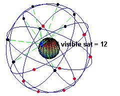
GPS satellites orbiting the Earth
Few days ago Google announced their free turn-by-turn GPS. The internet went crazy, especially the geeks. Getting out from the safety of your home, and all the comforts of the nearby kitchen, now that you have free turn-by-turn Google’s GPS was never easier!
Following that news, Garmin’s stock fell by 20%. Crazy!
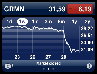
Wham, let the stock price hit the floor
No, what’s crazy is how the market reacts without thinking. The stock price is based on a lot of factors, but in this case the major factor is people’s willingness to continue to buy Garmin’s products when Google gives similar product for free (well, similar effect). And this just proves how people in general, en masse, are not very smart.
What you need to know is that Google’s GPS relies on your connection to the internet in order to download maps and data. On the hardware side, yea, the software will use your device’s GPS antenna and GPS constellation to detect it’s location, but that location is meaningless until you see it on a map. And that data will come down via internet. On the other side is Garmin, who has maps stored inside the device, and Garmin does not rely on the internet. All the data is physically stored inside the device. This has it’s drawbacks, main one being that you need to actually buy detailed maps in order to load them into device.
But think about this for a second. Better yet, check this map:
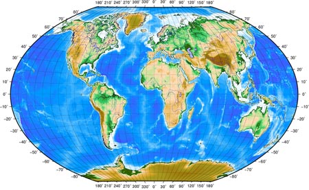
The areas marked blue on this map, so called – sea, is where there is no mobile internet coverage. I will save you the Wiki, that’s 70.8%. Basically, you can forget Google’s GPS there.
Then, let’s get real for a moment here, and admit to ourselves: the availability of sufficiently fast mobile internet is limited to the city areas. Even inside cities (at least here in Zagreb) the 3G coverage is so-so. Even if “ordinary” mobile internet speed was sufficient to use Google’s free GPS, that speed will only be sufficient to download data at walking speeds. If you are driving in your car on the highway, the combination of your speed plus lack of real broadband will lead to serious problems. Google’s software will say “TURN LEFT NOW” and you will already be in the next city, not the one you wanted to go to.
And I do not see this changing in the nearby future. I just cannot imagine telecoms saying: “Yea, it is a great idea for us to invest millions of dollars in hardware just so you could have wireless broadband internet in the middle of the Amazonian forest.”
Internet based GPS cannot be used in cars, cannot be used on ships and aeroplanes. It can hardly be used in the nature, trekking, biking, etc. It can be used while you walk from your door to the pub around the corner. This could be useful when you get drunk – it could probably yell at you and navigate you back home.
27 thoughts on “Google Free GPS vs. Garmin”
November 3, 2009 at 17:52
Haha yeah! The idea of Google GPS replacing Garmin GPS is propostrous! :)
Google GPS could at it’s best be used in Android phone as a feature that mashes up several google services at once in combination with geolocating. Walking speed. :)
November 4, 2009 at 00:07
Insightful post, except for missing out on the fact that people in Google aren’t stupid and that mobile apps can cache data.
November 4, 2009 at 00:18
Yea, caching is nice feature, except it has two problems.
A) only one zoom level is cached. For example, you look at the map at one magnification, and then decide to zoom in while you are offline. Or zoom out. Will not work.
B) what good is a GPS that relies on cached data. Cached data means, most likely, that you have visited tha location. Therefore, your device cached it. So why do you need GPS there again? If you used GPS to come from point a to point b, next time it is really not so likely you will need GPS again! :)
November 4, 2009 at 01:24
I get your point. However, first hand experience sheds a different light — I was headed to Budapest for the first time in my life this summer (for a concert). Being a first timer there, I popped up my blackberry curve 8310 (which I had on me at the time) which had only Google maps app installed. Found the concert venue I in no time, without any problems or wandering around. Clear, turn-by-turn instructions worked like a charm.
So, it’s usefulness is undeniable — even though it’s free, and even though it might be unavailable at times. Had I gotten a hint of places to stay at, or places to go to during that time, I’ve would’ve taken that advice no questions asked. And I think that’s what Google is going for (as a first step at least, until every tiny corner of the Earth has proper coverage).
Just sayin’.
Proper GPS apps are irreplaceable (especially if you’re “discovering new grounds”), but free apps such as Google Maps definitely have a market of their own.
November 4, 2009 at 23:07
zytzagoo: and then you came back home and got mobile phone bill. roaming data prices are real bitch.
First time when I was in Budapest I had paper map with me. Damn I hate paper maps! There is no fucking way to open it in the car (it’s too big) or to search something when night falls.
Damn I love my GPS and i don’t go anywhere without it. :)
November 5, 2009 at 09:59
I guess none of you tried to install MapThis on PSP and GPS addon for PSP.
http://deniska.dcemu.co.uk/mapthis-0-5-20-with-holux-support-for-slim-psps-79825.html
Desired map location from Google Maps (with every possible zoom level) are downloaded on PS and saved on PSP memory card, it is no rocket science to build an application for Android that has a similar feature.
November 5, 2009 at 10:22
Hm hm hm, that sounds plausible. So I plan a trip to Sweden, from Croatia, and then that software downloads all zoom levels on the road from here to Sweden.
Isn’t that like two hundred Gjizillion bytes of data?
And what happens when I want to take a different route (as it happened to me because ferry boat from one side of Denmark was not operational, so I had to detour to the other side of Denmark)?
I mean, boys, do not get me wrong, internet based GPS is cool, and imma let him finish, but real satellite GPS has the best solution so far.
November 5, 2009 at 11:07
Yeah, statement about downloading google maps locally is close to downloading whole internet on your computer. :)
November 5, 2009 at 11:15
I agree the there would be “two hundred Gjizillion bytes of data”, which makes the whole thing unusable for trips from Croatia to Sweden.
The only problem that I see with Google Maps are PNG images that are used to store and display routes in Google Maps.
They could change this, and use some kind of vector technology (eg SVG) that overlays real satellite images that are downloaded from the cloud. When you are offline, only routes are displayed.
November 5, 2009 at 12:36
Yea, and give VECTOR representation of the entire world, with details of each street for free. Hmm hm hm, I smell a problem there =)
November 5, 2009 at 19:47
Hmm, hmm, and what smelly problem is that ? :)
Guess you also did not hear about OpenStreetMap
http://en.wikipedia.org/wiki/OpenStreetMap
November 5, 2009 at 22:14
There are a lot of things I “also” didn’t hear about. No need to get smug about it.
The wiki idea is great, and I respetc all the people that contribute onto any wiki, but wiki is hardly accurate on a lot of topics, and I have proven that wiki can be manipulated ( I have inserted one friend to be Anti-pope ). As a mental test imagine you sit on a plane and pilot says: on this flight we will be flying using open source wiki based naviation. The plane would empty faster than if it was fire-drill.
November 8, 2009 at 13:40
PNG maps are zillion times faster to show on the client side than to render vector ones. Try zooming and moving the map of any larger city on Garmin using max details…. slooow. But detailed. :) Doing the same on computer is a bit faster, but not as fast as moving bitmap images around.
On other hand.. what REALLY pisses me off is the level of details all those map services have for our region. I can zoom-in on my friends house in Netherlands and see him taking a dump. In high-res.
November 24, 2009 at 01:37
I think you’re not seeing the big picture and are a bit stuck in there
Googles stuff evolves, *FAST*
That’s why the stocks have plumited, ’cause stocks are also about the future.
If google releases something right now, it will mean you will have incremental updates every couple of months, for free, instead of every X years if you can cough up the money. Also, this stuff is hooked up to the world in a way that scares the current producers like Tomtom and Garmin and makes the minds of nerds around the world buzz.
The fact that you have thought of these (potential) problems here, probably means that someone at google did too, and they are already working on it. In a a couple of releases, you can probably just plan and download the whole route you’re going to drive, i can imagine even different kinds of packages depending on what you’re data plan is ( unlimited access will also download streetview material of the upcoming turns or so if available, roaming you will just download the map and terrain data)
November 27, 2009 at 14:52
Duckie, the issue here is not Google, it is the infrastructure that Google relies on in order for Google GPS to function. I just do not see telecoms making a decision to enable high speed internet infrastructure anywhere outside cities and main highway routes. It costs really a lot of money to get all that hardware in the middle of some forest just so you could go 3G there.
Therefore, Google’s evolution here is not stopped by them – it is stopped by infrastructure provided by others.
November 27, 2009 at 14:56
@Daemon: Why is that a problem if a full-fledged GPS receiver can fit in a coin these days? How many new phones have no GPS these days?
The ‘Google GPS’ is just a fallback and ofcourse only nessecary if there is no real GPS. I don’t see the problem.
November 27, 2009 at 15:47
Because GPS just gives you the coordinates and is not the issue here. Maps are the issue.
You need map so you can visually see where that coordinates are and use that to orientate yourself in space. Traditional GPS devices (Garmin, Tom Tom) have those maps as preloaded vectors that you buy.
Google, in order to display your position on a map requires your device to download maps in realtime from the internet (i do not acknowledge map preloading as an option). Thus, if you do not have rather fast mobile internet connection – you are screwed.
Yes, you will always know your X Y coordinate, but a number 45,5456456 16,2134234 is pretty meaningless unless you can see it on a map.
November 27, 2009 at 15:51
I repeat myself: i don’t see the problem. I’ll donate my monthly salary to charity if they’ll let themselves be held back by this.
November 27, 2009 at 15:59
Donate it to me, it will be more effective =)
So, you see Google becoming Telecom. Well, that is not impossible, I would like that as well.
November 27, 2009 at 22:35
I second Google Telecom idea!
If you guys take a look at Chromium OS and Google Apps in general, nothing works without Internet connection. Personally – I am not big fan of storing my data on a cloud for which I am not 100% sure I will be able to access when I will need.
Don’t get me wrong – if I would be online ALL THE TIME, EVERYWHERE in the world (I could possible find my self), I would use this, and never look back at local data storage (be it documents or world maps), and I ofcourse – I would be biggest preacher of Googlism. :)
But we are still far from there yet (I think we are at the same distance to that as we are from free electric energy) and therefore we have right to judge this idea.
October 28, 2010 at 11:40
Garmin GPS are the best, i accidentally dropped one on the pool and it is still functioning after a minor cleanup”,-
November 14, 2010 at 15:46
i use Garmin GPS whenever i go out, Garmin GPS is very reliable ‘~*
December 29, 2010 at 21:39
@Daemon
http://www.nivas.hr/blog/2009/11/03/google-free-gps-vs-garmin/#comment-675549
And here we are, 1 year later with new Google Maps for mobile featuring vector graphics and offline maps.
March 22, 2011 at 15:36
Just went on a little road trip Upstate NY last weekend, used my T-Mobile G2 with Google map turn by turn and it worked flawlessly… No doubt in the middle of the Ocean or desert, a real GPS is necessary, but for North America, it works awesome… if you’re not on ATT I’m guessing ;)
March 28, 2011 at 22:49
or if you travelling abroad, data roaming charges will cost like one whole trip alone.
tomtom for iphone worked for me pretty well so far. and standalone garmin device. they both have offline maps.